
Whether to help conservation managers set hunting limits for mule deer, aid rangers in poaching prevention on African wildlife reserves, or helping public health officers in reducing the prevalence of diabetes in rural India—the tools of data science are increasingly being applied to fields where their utility has historically been less obvious.
But in an ever more data-driven society, the insights data science tools provide can be invaluable in decision making. Three University of Oregon researchers prove the efficacy of these tools in a variety of scenarios.
Simulating animal populations on the landscape to aid wildlife managers
For decades, human management of wildlife populations has depended on capture, tag, release, and recapture; counting numbers harvested during hunting season; motion-triggered trail cameras; and more recently, microchipping. But these methods can be expensive and time-consuming. A simulation tool in development at the University of Oregon offers wildlife managers a new way to track species populations and overcome traditional challenges to doing so.
Gilia Patterson, a doctoral student affiliated with the Institute of Ecology and Evolution (IE2), is using genetic data, GIS, and convolutional neural networks—deep learning, image recognition algorithms—to build flexible models that can use simulations of a population of a given species on a specific landscape to infer how big the population is.
It was the lack of such a tool that inspired the project. In response to the Bureau of Land Management’s Desert Renewable Energy Conservation Plan, Peter Ralph, associate professor of biology and mathematics in the College of Arts and Sciences and a member of IE2, worked with collaborators who had generated a DNA dataset of desert tortoises in the Mojave. They examined how the solar energy installation could affect habitat continuity and potentially fragment tortoise populations, leading to decreased genetic diversity of the already threatened species.
“In working on that project, I noticed that much of wildlife management is people doing simulations in their heads,” Ralph said. “Being able to run through scenarios on the computer is helpful to check assumptions. The other thing computer simulations are useful for is inference—for instance, to learn what the migration rate has been between two locations, we can tweak the ‘migration knob’ on a simulation until it looks like data collected in the field.”
One such assumption is how pockets of animals might interact with each other when there are geographic barriers, like mountain ranges or vast distances without water. To that end, Patterson is importing maps of landscape types derived from satellite images, which will help conservation managers realistically estimate population sizes spatially. The resulting maps and simulations could then be used to try out different management scenarios. For example, the tool might in the future be used to manage sage grouse or mule deer populations in eastern Oregon or to run population viability analyses of dwindling populations like the vaquita porpoise—just 10 of these rare marine mammals remain—or the Pacific fisher.
For most animals, Patterson said, “it’s just not practical to count the number of individuals. We are estimating density across the landscape using data that doesn’t require animal capture and is easier to collect.”
Another perk of the simulation-based tool is that it can use data from many different sources, from camera trap observations to genetic samples that lets scientists identify parent-offspring pairs. These genetic samples might come from captured or hunted animals but could also come from scat or fur snagged on foliage.
Ralph and Patterson are currently developing and testing the statistical methods needed for the tool, while developing collaborations with managers and wildlife researchers to use the tool. A goal of the tool is that it is generic enough to serve as a starting point that wildlife managers can tailor to particular situations, such as modeling the effects of inbreeding if a species is confined to a certain spatial extent. Additionally, Patterson noted that not everyone has access to massive computing power; their tool uses simulations and neural networks that run quickly, removing the need for a conservation office to maintain a supercomputer for that purpose.
“In the past, population genetics and theory have ignored geography. But we don’t live on a flat table,” Patterson said. “Interaction with the landscape is really relevant to our understanding of how populations grow, shrink, or evolve.”
Applying lessons learned from an anti-poaching app to diabetes prevention efforts
During her graduate studies, Thanh Nguyen helped build the Protection Assistant for Wildlife Security (PAWS) app, an artificial intelligence that uses game theory and machine learning to help wildlife preserve rangers in eastern African nations prevent poaching. The assistant professor of computer and information science in the College of Arts and Sciences said that the app incorporates ranger observations, such as snares or poaching signs, along with terrain information like locations of rivers, roads, and villages into a game theoretic framework.
“It’s essentially a strategic game between rangers and poachers,” Nguyen said. “The app helps rangers detect and prevent poaching by modeling poacher behavior.”
Just as PAWS is built on behavior models, so too is Nguyen’s latest work with the nongovernmental organization (NGO) Arogya World, which is focused on Type 2 diabetes prevention in India. Nguyen was paired with Arogya World through Google’s AI for Social Good program. By working together, they build an effective AI-based message generation system for diabetes prevention in rural areas in India, where the diabetes rate has been increasing at an alarming rate. The messages contain information about diabetes causes and complications and the impact of nutrition and fitness on preventing diabetes.
“Diabetes is a big health problem in India,” Nguyen said. “Diabetes is preventable with lifestyle changes, such as eating healthy food and increasing physical activity. Yet barriers in underprivileged regions often prevent engagement in these activities, particularly poor education about the disease, lack of social support, and limited healthcare access.”
To that end, Nguyen and Arogya World are fine-tuning an effective messaging intervention system that dynamically sends personalized messages to participants through WhatsApp.
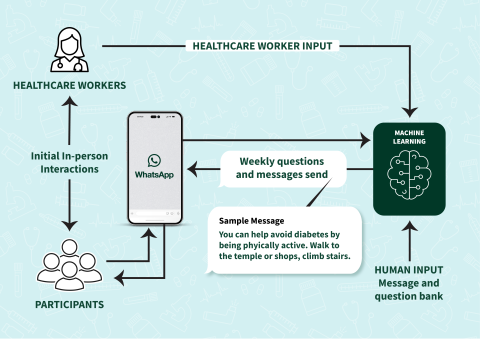
“We chose WhatsApp to transmit the messages since mobile phone uptake is high in India, and WhatsApp is an essential communication channel that is accessible to almost everyone.”
Nguyen’s research group proposes to apply reinforcement learning to optimize the message selection policy over time, tailoring their messages to align with each individual participant's needs and preferences. Reinforcement learning captures how people learn through their experiences and interactions in the context of their environment, which is fed back into the machine learning model to adjust messaging content.
Ironically, Nguyen said that working with NGOs has been a live-action reinforcement learning experience for her.
“I’ve learned how to communicate with people who are working in the field, and they speak in a different language than computer scientists. They use a different language to convey the aim of the models we have,” she said. “When we build models, we make a lot of assumptions. But when you go into the field, it’s completely different. For example, looking at a map you may think the rangers can go anywhere in a wildlife preserve, but that’s not the case—they can’t just walk straight up a cliff. Working with people in the field helps update the models.”
Nguyen said she became involved in partnering with NGOs because she wants to have an impact on society beyond the circle of academia. She notes that the projects she works on are meaningful, but by no means fast.
“These are long-term projects. They don’t have immediate rewards,” she said. “It took several years to get real-world results that improved our models to in turn improve ranger patrols. It took two years to deploy the messaging app with health workers in India.”
But Nguyen isn’t interested in quick fixes; she’s interested in impact.
“AI is now everywhere and can offer us solutions to societal challenges to help people,” Nguyen said. “In this case, AI can help people living in developing countries who do not have access to good education or health care systems. We can use these tools for social good.”