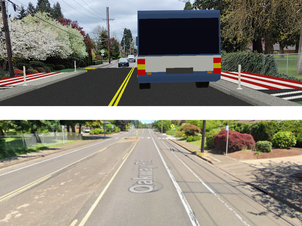
Changing Negative Perceptions of Change
Urban planning projects, whether they involve redesigning streets, building high-density housing, or creating public spaces, often face significant challenges.
One such obstacle is the disconnect between project goals and public perception. In theory, people may support ideas like sustainable infill housing or safer, bike-friendly streets, but in practice, the idea of change in their own neighborhoods can be met with resistance.
While excoriated as excessive red tape, zoning and permitting often serve to remove uncertainty from the built environment. But when it’s hard to imagine what proposed changes would look like and how they would affect the feel of a neighborhood, the public tends to default to a “no” vote, which can stall or kill beneficial projects.
Without clear and proactive engagement strategies, the gap between what communities across the nation say they want and what actually gets built only widens. Marc Schlossberg and Danny Pimentel, two researchers at the University of Oregon, are taking steps toward the development of new public engagement strategies using augmented reality (AR) technology to help people experience the potential benefits of these projects.
Augmenting Reality to Visualize Change
In 2023, Schlossberg, professor of city and regional planning, and Pimentel, assistant professor of immersive psychology, received $50,000 from the UO’s Incubating Interdisciplinary Initiatives (I3) Award Program to begin the work of developing customizable, real-time, augmented reality tools for street redesign. Funding programs like I3 enable exploration of cross-disciplinary solutions to problems facing society that private companies typically deem too risky without the kind of testing higher education research spaces facilitate.
While initially conceived to help cities reduce car dependency and carbon emissions, Pimental and Schlossberg realized the promise AR also holds for addressing the housing unaffordability crisis facing the US.
But first, what is augmented reality? Think about Pokémon Go, the popular game that uses mobile GPS to locate virtual Pokémon characters, which appear as if they are in a player’s real-world location when looking through a phone. AR combines the backdrop of the real world with overlaid digital information with the ‘low-tech’ of one’s everyday phone or tablet.
While Pimentel and Schlossberg’s efforts won’t help you catch ‘em all, they did conceive of an AR workflow to help people envision urban changes in real time and space. The process involves several steps: start with a 2D design in StreetMix, import it into a 3D model with 3DStreet, and then spatially anchor AR designs through Adobe Aero software.
If that sounds complicated, it is, particularly from a computing standpoint.
“We’ve come to find out that our idea was really bold,” Pimentel said. “In the AR space, most projects focus on an object like a person (or Pokémon) or at most a room. We’re working at a scale that is pushing the limits of this technology. More investment is needed to be able to use this technology at scale.”
Along the way, Schlossberg and Pimentel became acquainted with two software developers interested in urban design—Kieran Farr, who created the open-source program 3DStreet out of a desire to make streets in his California town safer for his children, and Roelof Pieters, a Dutch software designer also trying to make tools that help people in the Netherlands re-imagine streets as places that serve a broader public than primarily for the movement and storage of private vehicles.
Enabling Positive, Efficient Urban Planning
While 3DStreet works particularly well for the computer-savvy, one of Schlossberg and Pimentel’s more ambitious goals is the development of a plug-and-play phone app that enables users to easily place and manipulate 3D objects, like bike lanes or apartment buildings, in real-world settings. The researchers imagine city planners hosting meetings with residents to collaboratively “walk through” redesigned streets or view housing models in their neighborhoods with the ease of looking through a phone screen.
You can read more about the use of augmented reality in public infrastructure planning, such as whether to add protected bike lanes to a once-sleepy but now busy street, on Schlossberg's Substack.
“Public processes can be so burdensome and time-consuming, and it often amplifies the loudest, most negative voices in the room,” Schlossberg said. “If there’s a way to alter that public engagement to help people collaboratively visualize change in their communities, that technology could alter the conversation from ‘yes or no’ to an opportunity for constructive dialogue. We hope to facilitate effective communication without technological barriers to participation.”
Many Americans are increasingly priced out of owning a home because demand far outstrips supply—AR tools could help reduce the obstacles to new builds not only in Oregon, but across the nation. Rather than reacting out of fear of the unknown, the public could make informed decisions about urban planning initiatives, helping to accelerate project approval and implementation.
“Our nation is investing a lot of money in new infrastructure, and our cities and states are finally stepping up to figure out how to build more housing,” Schlossberg says. “Accelerating the implementation of these needed community investments by reducing opposition, simply by helping more people ‘see’ projects that are often hard to visualize, is an extremely exciting and potentially huge cost-saving opportunity. We are excited to continue this path of applied research that serves the public good.”
